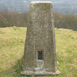
PillarThe classic trigpoint and a welcome sight for hill walkers everywhere! A concrete pillar about 4' high, with a flush bracket near the base and a circular plate on top with groves for mounting a theodolite. There are 6987 pillars listed in the T:UK database. Whilst most of them have fallen into disuse, about 264 of them are currently used in the Passive Station network. |
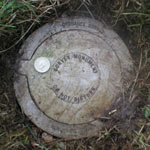
FBM - Fundamental BenchmarkAn underground chamber topped with a short granite pillar. The pillar contains an easily accessible height reference point, but the accurately measured level is underground where it is less likely to be disturbed. There are approximately 207 FBMs across the country and whilst many have fallen into disuse, about 200 have been incorporated into the National GPS Network as Passive Stations. For a detailed breakdown of the different types of FBM, see Ian Richardson's FBM styles - A Pictorial Guide. |
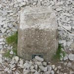
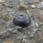
Surface BlockSurface blocks are part of the network of Passive Stations. There are 1284 surface blocks in the T:UK database. |
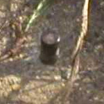
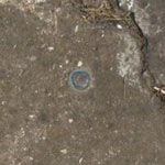
RivetRivets are part of the network of Passive Stations. There are 1229 rivets in the T:UK database. |
BerntsenBerntsens are part of the network of Passive Stations. There are 103 Berntsens in the T:UK database. See www.berntsen.com. |
BoltBolts are part of the network of Passive Stations. There are 4247 bolts in the T:UK database. |
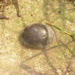
BlockBlocks are part of the network of Passive Stations. There are 2029 blocks in the T:UK database. |

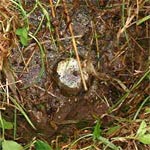
Buried BlockBuried blocks are part of the network of Passive Stations. There are 2597 buried blocks in the T:UK database. |
CentreCentres are part of the network of Passive Stations. There is 0 centre in the T:UK database. |
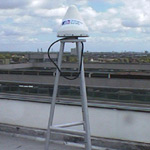
Active StationThere are 196 active stations in the T:UK database, (including those which are no longer used), which are sited at about 30 locations around the country. These are GPS receivers which constantly log their readings (known as Rinex data) on the Ordnance Survey website. This allows a very high level of positional accuracy to be achieved, without the need to physically occupy one of the Passive Stations. |
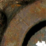
Flush BracketFlush brackets were fixed to walls at 1 mile intervals between FBMs. They consist of a metal plate with a unique number. There is also a horizontal mark with three vertical marks pointing towards it from below (the same mark as was carved into walls for lower order benchmarks). Flush brackets which are fixed to walls are not included in the database. However, triangulation pillars also boast a flush bracket near their base. Of the 6987 pillars in our database, we only know the FB numbers of 6974 of them! Please help us fill in the gaps. |
The vast majority of the old triangulation pillars, and most of the FBMs have fallen into disuse. While the Ordnance Survey have a database of their locations, it is not maintained and they have no interest in the current state of repair of individual trigpoints (unless they are a safety risk). A number of groups (eg the Ramblers Association) have "adopted" individual trigpoints and keep them in good repair. Passive stations which have been removed from the network will also fall into this category.
There are currently 196 stations in the active network, located at about 30 sites across Great Britain. These are transmitters which, when used in conjunction with the Rinex data provided by the Ordnance Survey, allow a very high level of positional accuracy to be achieved, without the need to physically occupy one of the Passive Stations.
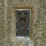
There are currently 1073 stations in the passive network. These are accurately surveyed locations around the country which, unlike traditional pillars and FBMs, are both easily accessible and give good accuracy for both position and height. An online database of passive stations is maintained by the Ordnance Survey.
Most of the stations in the active and passive network are new and have no prior use.
A set of around 406 triangulation pillars constituted the primary network. These were surveyed between 1936 and 1962 and can be considered the "backbone" of the triangulation network.
A set of around 2743 triangulation pillars constituted the secondary network. These "filled in the gaps" between the primary stations.
An underground chamber topped with a short granite pillar. The pillar contains an easily accessible height reference point, but the accurately measured level is underground where it is less likely to be disturbed. There are approximately 207 FBMs across the country and these provided the primary layer of the "Ordnance Datum Newlyn". Levelling between these locations provided accurate height information, though the horizontal location was less well determined than for the triangulation pillars.
Decommissioned active stations (see above).
Decomissioned passive stations (see above).
You may have noticed that some of the figures given above are inconsistent. This is because the data held in this database is incomplete and often self contradictory. For example, the number FBMs in the country is quoted as being 207, whereas the number of trigpoints whose historic use was as a FBM is 207. This does not sit well with the assumption that no new FBMs have recently been built, eg for the passive network. It is hoped that as people log their finds on this site, we will in time build up a better picture of what's out there, and "clean up" the data in the database.