![[UK map]](/img/locationmap.png)
| OSGB36 trig archive spreadsheet - IW | |||||||||||||
|---|---|---|---|---|---|---|---|---|---|---|---|---|---|
| Trig Name | Original Name | New Name | EASTING | NORTHING | HEIGHT | ORDER | TYPE OF MARK | Computing Date | CLASS OF LEVELLING | Date of Levelling | LEVELLING DATUM | DESTROYED MARK INDICATOR | COMMENTS |
| Great Clump | SE44/T67 | SE44T067 | 448848.74 | 420529.47 | 53.504 | 4 | PILLAR | 01/06/1947 | 1 | 01/10/1959 | N | 1 | Dest 08/79 |
Nearby trigpoints, placenames
There are 14 photos for this trigpoint (view album).
This trigpoint:
Is ranked joint 24984th with 33 other trigs (more).
Has a mean score of 1.80/10 (from 41 logged visits)
Was First logged: 3rd Jun 2001
Has never been found intact
Was Last logged: 17th Apr 2024
Of the 41 logged visits,
4 recorded a location and of these....
All were within 100029m
The average error was 25021m
2 were exact
You are not logged in. You must login if you wish to log a visit.
| Selection of photos for this Pillar. ©Mark-UKUS 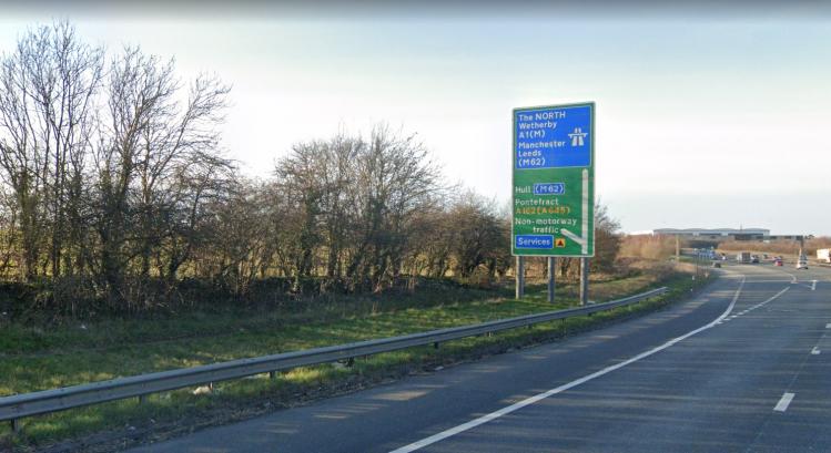 By BasilDowl 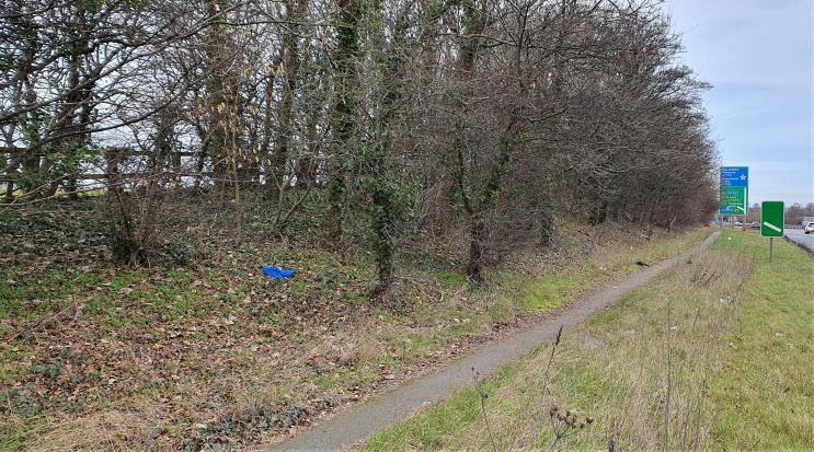 ©eon 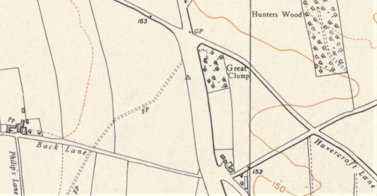 ©eon 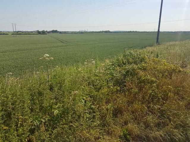 By asbown 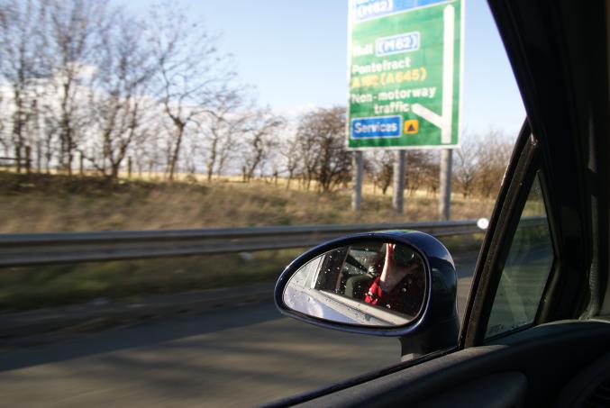 By rowleybirkin 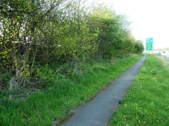 By peregrinus See 7 more in the album. |
![]() 17th Apr 2024 00:00 by Ronaldo333
17th Apr 2024 00:00 by Ronaldo333
FB Number: Not logged Condition: Not Logged Score: 5/10
Great Clump S4158 Dest. From GR: SE 48447 20377. Easier parking and cut through to the PROW footpath from SE 48626 20315
![]() 30th Dec 2023 13:40 by nichex
30th Dec 2023 13:40 by nichex
FB Number: Not logged Condition: Destroyed Score: 1/10
A1 drive by at walking pace due to roadworks.
![]() 23rd Oct 2023 14:27 by BeckyP52
23rd Oct 2023 14:27 by BeckyP52
FB Number: Not logged Condition: Unreachable but visible Score: 5/10
Bagged as we passed on the motorway.
![]() 16th Aug 2023 15:09 by Mark-UKUS
16th Aug 2023 15:09 by Mark-UKUS
FB Number: Not logged Condition: Destroyed Score: 3/10
As with many other, I would have been over this spot about a million times before, but thought we should should try and get an appreciation for its location. Parked up by 17 Mill Hill Close and followed the FP running between he houses towards the A1. Rather than follow the path onto the road, continued left up the hill to the approximate location. Not the finest of walks, but at least now I have a bit of a feeling for the site, plus its only a 15 min detour off the A1. Rewarded ourselves with a nice pint of of Timmy Taylor Landlord at The Spread in the village.
![]() ©Mark-UKUS
©Mark-UKUS
![]() 23rd Apr 2023 14:22 by BasilDowl
23rd Apr 2023 14:22 by BasilDowl
FB Number: Not logged Condition: Destroyed Score: 1/10
A drive-by only, heading northbound on the A1; as others have mentioned, the OS archive states that this was destroyed in August 1979, presumably for the road expansion. Photo approximate location only.
![]() 23rd Mar 2023 13:51 by FrankR
23rd Mar 2023 13:51 by FrankR
FB Number: Not logged Condition: Destroyed Score: 2/10
![]() 10th Feb 2023 10:26 by eon
10th Feb 2023 10:26 by eon
FB Number: Not logged Condition: Destroyed Score: 1/10
(2861) Parked at the top of Sotheron Croft - Mill Close in retrospect would have been better - and then followed Back Lane to the A1 and then headed N to the pillars location. Nothing to see of course. Pillar history: Built on the 20th of September 1947, build cost and a last maintained date not present in the archive. Marked as destroyed in August of 1979. FB was S4158.
![]() Map c1953 ©eon
Map c1953 ©eon![]() General location ©eon
General location ©eon
![]() 11th Nov 2022 13:52 by A1Mushroom
11th Nov 2022 13:52 by A1Mushroom
FB Number: Not logged Condition: Destroyed Score: 5/10
Long gone
![]() 16th Oct 2022 10:30 by Mickandkim
16th Oct 2022 10:30 by Mickandkim
Gridref: SE 48800 20500 FB Number: S4158 Condition: Destroyed Score: 3/10
Drive over spot
![]() 16th Oct 2022 00:00 by painterman61
16th Oct 2022 00:00 by painterman61
FB Number: Not logged Condition: Destroyed Score: 5/10
drive by
![]() 11th May 2019 16:03 by martin cliff
11th May 2019 16:03 by martin cliff
FB Number: Not logged Condition: Destroyed Score: 2/10
knew it wasn't here,checking to see if i could see it's neighbour from this location
![]() 7th Apr 2018 16:15 by dugswell2
7th Apr 2018 16:15 by dugswell2
FB Number: GONE Condition: Destroyed Score: 5/10
Long gone.
![]() 8th Aug 2017 01:42 by Ant1974
8th Aug 2017 01:42 by Ant1974
FB Number: Not logged Condition: Destroyed Score: 5/10
![]() 19th Jun 2017 10:58 by asbown
19th Jun 2017 10:58 by asbown
FB Number: Not logged Condition: Destroyed Score: 5/10
drive by only.
![]()
![]() 7th Apr 2017 13:51 by Particle
7th Apr 2017 13:51 by Particle
FB Number: Not logged Condition: Destroyed Score: 3/10
![]() 18th Mar 2017 00:00 by rupertal
18th Mar 2017 00:00 by rupertal
FB Number: Not logged Condition: Destroyed Score: 2/10
![]() 21st Feb 2014 14:30 by rowleybirkin
21st Feb 2014 14:30 by rowleybirkin
FB Number: Not logged Condition: Destroyed Score: 1/10
Must have passed by this spot countless times over the years back as far as 1968 I would guess. This one will always remain a 'drive-by' as far as we are concerned and I thank others on this site who have taken the trouble to seek out remains of pillar and provide information to save us the trouble.
![]() 2nd Oct 2013 00:00 by dogwalking
2nd Oct 2013 00:00 by dogwalking
Gridref: SK 48800 20500 FB Number: Not logged Condition: Destroyed Score: 0/10
![]() 19th Mar 2013 17:15 by The RockKnocker
19th Mar 2013 17:15 by The RockKnocker
FB Number: Not logged Condition: Destroyed Score: 0/10
It might have been used as hard core in the new road.
![]() 22nd Aug 2012 17:58 by CJO
22nd Aug 2012 17:58 by CJO
FB Number: Not logged Condition: Destroyed Score: 1/10
Drove past north bound, my standards drop a little for destroyed pillars.
![]() 20th Apr 2012 16:59 by peregrinus
20th Apr 2012 16:59 by peregrinus
FB Number: Not logged Condition: Destroyed Score: 2/10
Site is now verge of N-bound c/way, at foot of embankment: trig would have been maybe 5m above current ground level. Parked in village and walked in from SW. Various lumps of concrete along highway fenceline make a bit of an effort with an impression of a centre hole but I suspect they're just drainage-surround-related. OS trig archive states Destroyed 08/79
![]() 2nd Mar 2012 19:36 by PeteBoggs
2nd Mar 2012 19:36 by PeteBoggs
FB Number: Not logged Condition: Destroyed Score: 1/10
Nothing to see
![]() 25th Oct 2011 16:54 by craftinessa
25th Oct 2011 16:54 by craftinessa
FB Number: Not logged Condition: Destroyed Score: 0/10
Probably under the A1, certainly missing
![]() 25th Oct 2011 16:54 by swampysean
25th Oct 2011 16:54 by swampysean
FB Number: Not logged Condition: Destroyed Score: 0/10
![]() 16th Oct 2011 17:50 by Rachel-C
16th Oct 2011 17:50 by Rachel-C
FB Number: Not logged Condition: Destroyed Score: 5/10
![]() 10th Oct 2011 16:19 by Border Peat
10th Oct 2011 16:19 by Border Peat
Gridref: SE 48849 20529 FB Number: S4158 Condition: Destroyed Score: 3/10
Road cut in half with the A.1 Trunk road.
![]() 5th Oct 2011 10:18 by tigger4242
5th Oct 2011 10:18 by tigger4242
FB Number: Not logged Condition: Destroyed Score: 2/10
long gone
![]() ©tigger4242
©tigger4242
![]() 19th Apr 2011 13:41 by johnbamforth
19th Apr 2011 13:41 by johnbamforth
Gridref: SE 48849 20529 FB Number: N/A Condition: Destroyed Score: 0/10
Log #75. (50m). Leg 3 of 8.3km x 3 trig linear walk from High Ackworth to Darrington. OS shows this trig to have been at 50m elev. Both the Grid ref and the 50m contour line show this to have been to the left of the A1(M) FP just inside the perimeter fence looking N. I climbed up the small bank to observe the high point of the arable field to the W of the hiway boundary fence, then lined up with the high point of the ground on the other side of the Motorway. This ties in with the Grid ref. The Grid ref of the boundary fence is 48844. Photo shows nothin but ground cover and trees with sidewalk down below. The whitish color to the L of that is actually a truck passing by.
![]() Great Clump The trigpoint (best calculation I can make) I'm facing S. The hiway and sidewalk is to the left. The perimeter fence and field is just to the o/s right of frame
Great Clump The trigpoint (best calculation I can make) I'm facing S. The hiway and sidewalk is to the left. The perimeter fence and field is just to the o/s right of frame
![]() 24th Jul 2010 16:00 by MAC.HAWK
24th Jul 2010 16:00 by MAC.HAWK
FB Number: Not logged Condition: Destroyed Score: 1/10
The minor road that is Spitalgap Lane that appears to traverse to A1(M) doesnt. I came (on foot) from the east along the road passing Hunters Wood to reach a dead end at the A1(M). I didnt fancy my chances crossing both lanes of the A1(M) so had to detour via Darrington. Where the minor road passes under the flyover a footpath immediately on the right follows the motorway up towards Spitalgap Lane (when it reaches the ROW heading west you can follow the - permissive path - that runs along the eastern edge of the field the trig might have been in). If you come from the west you cant drive a car down Spitalgap Lane - bike (push or motor) will do the job, but again its a dead end when you reach the motorway. Todays view was of a dying crop of whatever in the field. NCOF!
![]() 11th Jul 2010 13:00 by haighr01
11th Jul 2010 13:00 by haighr01
FB Number: Not logged Condition: Destroyed Score: 1/10
From Darrington take Philips Lane then down the path to the A1 - no path across field - at A1 head north following road. Poetically, the lumps of concrete near the high point could be the remnants of man's past endeavours taken by the road now without apology. Take the frankly once dangerous A1 junction of Spittalgap lane, now growing over, and follow Marl Pit Lane home. Nothing too great to see - on a clear day look North-East to the line of the Yorkshire Wolds, the Aire valley lies north. No Pennine view from here, try to spot Upton Water Tower on your return whilst admiring the former windmill on Moor Lane.
![]() Trig Murder Trig Murder
Trig Murder Trig Murder![]() Progress? Progress?
Progress? Progress?
![]() 26th Jan 2010 17:25 by Griefmiester
26th Jan 2010 17:25 by Griefmiester
FB Number: Not logged Condition: Destroyed Score: 1/10
nothing here - road widening looks like most likely reason.
![]() 22nd Oct 2009 12:45 by graeme1527
22nd Oct 2009 12:45 by graeme1527
FB Number: Not logged Condition: Destroyed Score: 0/10
![]() 22nd Oct 2009 12:45 by Trigbagger
22nd Oct 2009 12:45 by Trigbagger
FB Number: Not logged Condition: Destroyed Score: 0/10
Yep, the road must have claimed this one. I drive past here every week and never knew this one was (or wasn`t here) as it doesn`t show on memory map, only became aware of it thanks to the tom tom upload file.
![]() 20th Nov 2008 18:15 by splash
20th Nov 2008 18:15 by splash
FB Number: Not logged Condition: Not Logged Score: 1/10
Drove past the site on my way north.
![]() 28th Mar 2008 16:24 by Triggers
28th Mar 2008 16:24 by Triggers
FB Number: Not logged Condition: Destroyed Score: 0/10
Another one gone to progress
![]() 22nd Sep 2005 20:15 by rhayader_wanderer
22nd Sep 2005 20:15 by rhayader_wanderer
FB Number: Not logged Condition: Destroyed Score: 1/10
Drive by due most likely to dualing
![]() 24th Jul 2005 16:55 by Kev W
24th Jul 2005 16:55 by Kev W
FB Number: Not logged Condition: Possibly missing Score: 0/10
Believe it now part of the A1
![]() 20th Nov 2004 09:50 by ted
20th Nov 2004 09:50 by ted
FB Number: Not logged Condition: Destroyed Score: 0/10
A mini-mystery. Noted iainmac's log of 'couldn't find it'. According to the OS list this trig was S4158 and theres a photo with that number posted by Morseman to groups.msn.com/OSBM on 12/05/2003. So I wondered if I had somehow missed something and went for another look. Its still not there! Well-established wooden railings on the field side of the hedge are not shown in Morseman's photo so the trig must have been on the road side. But the saplings on the embankment are more that 2 years old and aren't shown in his photo either so could the trig have been moved? Found a few flakes of concrete at the highest point, but could have been from anything. Still a very noisy road.
![]() Great Clump View from across the road.
Getting across the A1 on foot is not recommended 8-)
Great Clump View from across the road.
Getting across the A1 on foot is not recommended 8-)
![]() 3rd Jul 2004 14:20 by ted
3rd Jul 2004 14:20 by ted
FB Number: Not logged Condition: Destroyed Score: 0/10
This section of the A1 is not (yet) classed as motorway so access on foot is possible. But if the older OS map's indication of the west side of the road is correct then I think this one has definitely gone. It should have been very close to the stile marking where the footpath joins the road. The trig is not shown on current OS 1:25000 or 1:50000. Checked both sides of the hedge but nothing. A very noisy road.
![]() map OS 1:50000 Sheet 105 (York) p.1977
map OS 1:50000 Sheet 105 (York) p.1977
![]() 31st Oct 2003 12:00 by iainmac
31st Oct 2003 12:00 by iainmac
FB Number: Not logged Condition: Couldn't find it Score: 0/10
I believe this must have gone when A1M made dual carriageway.
![]() 3rd Jun 2001 11:30 by sleepwalker
3rd Jun 2001 11:30 by sleepwalker
FB Number: Not logged Condition: Destroyed Score: 1/10
Thrashed up and down the hedgerow at the side of the A1 in hope but couldn't find any trace of the pillar.
![[map]](/img/trig-map.png.php?t=3452&b=2&l=0&)