Bilby towers
In their book on the Ordnance Survey, [1] Owen and Pilbeam state:
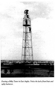
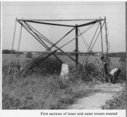
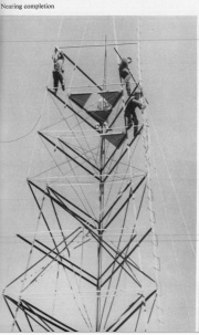
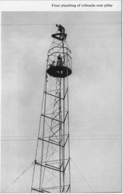
"The steel observing tower, called a Bilby tower, had been developed in America for surveying its vast flatlands and prairies. Each tower was in fact two independent structures. The instrument was supported on the inner tower and the observer and his assistant stood on the outer one. They needed careful erecting, including the laying of concrete footings for the legs. It was found to be easier for a trig pillar to be built under the Bilby tower, once it was in position. At full heights the towers rose to 103 feet and took about 10 hours to erect"
Further detail is given in History of the Retriangulation of Great Britain [2].
Bilby Towers were used extensively in the re-triangulation to elevate the theodolite position in order to provide a more extensive view.
They consisted of two separate towers one inside the other. The outer tower carried the observer and booker while the inner, totally independent, carried the instrument. The towers were guyed to the ground for stability. A height of 100ft was quite common, the highest may have been 120ft. They were constructed by a special team of labourers who specialised in erecting the Bilby Towers. The inner tower was plumbed precisely over the mark using a 10lb plumb bob, sometimes suspended in an oil bath to dampen the motion.
Bilby Towers were most commonly used in East Anglia. All the Towers were sold of in the 1980s, mainly for scrap. [3]
The following primary pillar stations had steel towers. [4] All these pillars were built in 1938 or 1939.
| Grid Ref | T:UK | PP | Station Name | Location |
|---|---|---|---|---|
| TQ 84340 11923 | TP0442 | 193 | Fairlight Down | Hastings, East Sussex |
| SP 89068 09997 | TP2394 | 204 | Coombe Hill | Tring, Buckinghamshire |
| SU 72344 95241 | TP0317 | 207 | Shirburn Hill | Wallingford, Oxfordshire |
| TL 78691 55857 | TP2132 | 236 | Chedburgh | Bury St Edmunds, Suffolk |
| TM 18240 53814 | TP0757 | 244 | Swilland | Ipswich, Suffolk |
| TM 25514 70170 | TP2636 | 260 | Crown Corner | Saxmundham, Suffolk |
| TG 26238 02646 | TP3258 | 261 | Framingham | Norwich, Norfolk |
| TG 02653 32999 | TP5438 | 263 | Piggs Grave | Sheringham, Norfolk |
| TF 40661 73018 | TP2772 | 265 | Dexthorpe | Alford, Lincolnshire |
| TF 64840 04270 | TP0374 | 424 | Crimplesham | Downham Market, Norfolk |
| TF 83913 09253 | TP6276 | 425 | Swaffham | Swaffam, Norfolk |
| TF 92508 10418 | TP3260 | 426 | Fransham | East Dereham, Norfolk |
| TF 50203 16622 | TP6713 | 427 | Walpole St Peters | Wisbech, Norfolk |
| TF 00079 03199 | TP2357 | 431 | Collyweston | Stamford, Northamptonshire |
| TL 06666 78508 | TP3128 | 432 | Fayway | Irthlingborough, Northamptonshire |
| TL 05880 59778 | TP7113 | 433 | Bolnhurst | Bedford, Bedfordshire |
| TL 64887 22350 | TP2925 | 437 | Dunmow | Braintree, Essex |
| SP 85120 98887 | TP6668 | 442 | Uppingham | Oakham, Leicestershire |
| SP 80590 75413 | TP0260 | 443 | Faxton | Northampton, Northamptonshire |
| TA 24842 18824 | TP6208 | 450 | Stone Creek | Withernsea, Humberside |
| TA 29825 33763 | TP6612 | 451 | Tunstall | Withernsea, Humberside |
| TA 39598 20679 | TP2781 | 452 | Dimlington | Withernsea, Humberside |
Bilby Towers were used also in the measuring of precise locations of the Radio telescopes at the Mullard Research establishment in Cambridge. [5]
References
- ↑ Ordnance Survey- Map Makers to Britain since 1791', Tim Owen and Elaine Pilbeam, p.123
- ↑ The History of the Retriangulation of Great Britain, Section 2.07 'Steel Observing Towers'
- ↑ email from Ian Wilson to the trigonomy mailing list
- ↑ email from Graeme Paterson to the trigonomy mailing list, 18/04/2012
- ↑ https://www.ordnancesurvey.co.uk/documents/resources/map-makers-britain-history.pdf#page=164 'Ordnance Survey- Map Makers to Britain since 1791', Tim Owen and Elaine Pilbeam, p.155


