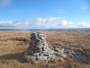
Cairn
From TrigpointingUK

A Cairn at Drumaldrace but possibly not the trig mark
Station marks of the old Principal Triangulation were usually buried, and only a few of the old primary and secondary stations were provided with some form of mark above ground level which normally consisted of a cairn, and then only when the station was on the top of a high mountain; see History of the Retriangulation of Great Britain [1]
A 'Cairn' is an uncommon type of mark in the Retriangulation. 16 instances, mainly in Scotland, are recorded in the OSGB36 list [2].
| T:UK | Station name | Order | Computed | Block |
|---|---|---|---|---|
| TP7922 | Beinn Dearg Cairn | 3 | 1955 | NC20 |
| TP7916 | Ben Griam More Cairn | 2 | 1954 | NC85 |
| TP7926 | Bogengarrie Cairn | 3 | 1953 | NK03 |
| TP7925 | Core Hill Cairn | 3 | 1952 | NK03 |
| TP7929 | Drumaldrace | 3 | 1955 | SE38 |
| TP7920 | Gars Bheinn Cairn | 3 | 1959 | NG24 |
| TP7917 | Great Bernera | 4 | 1961 | NC20 |
| TP7551 | Killegray | 4 | 1957 | NG24 |
| TP7924 | Mealfuarvonie | 3 | 1955 | NH40 |
| TP7928 | Prince Alberts Cairn | 3 | 1956 | NJ40 |
| TP7630 | Queensberry Cairn | 3 | 1954 | NX99 |
| TP7927 | Rosinish | 4 | 1957 | NG24 |
| TP7921 | Sgurr A Choire Ghlais | 3 | 1955 | NH54 |
| TP7923 | Suidhe Ghuirman Cairn | 3 | 1955 | NH54 |
| TP7918 | Suilven Cairn | 3 | 1955 | NC20 |
| TP7919 | The Stack (Stack Islands) | 4 | 1957 | NG24 |
Given the impermanence of cairns, with passers by liable to add or remove stones, perhaps rebuilding or even relocating them, then it is surprising that only Drumaldrace is recorded by the OS as 'destroyed'.
References
- ↑ The History of the Retriangulation of Great Britain 1935-1962, Section 2.06
- ↑ https://www.ordnancesurvey.co.uk/legacy/docs/gps/CompleteTrigArchive.zip