Fenomark

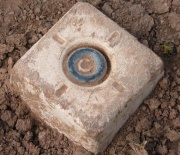
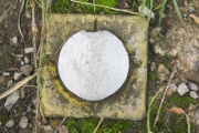
A Feno Marker is a type of survey marker, developed by the French company Faynot, which is quick to install and well anchored [1]. 15 instances occur in the OSGB36 list [2]. A listing is available from T:UK
| T:UK | Station name | Order | Computed | Block |
|---|---|---|---|---|
| TP7808 | Cattlelaith Lane | 13 | 1987 | SE44 |
| TP7808 | Cattlelaith Lane | 13 | 1989 | SE44 |
| TP7807 | Kings Standard Hill (1987) | 13 | 1987 | SE44 |
| TP7793 | Spitalgap Lane | 13 | 1987 | SE44 |
| TP7793 | Spitalgap Lane | 13 | 1989 | SE44 |
| TP7451 | Gibbet Hill | 3 | 1989 | SK73 |
| TP7792 | Woodlands | 3 | 1987 | SE44 |
| TP7839 | New Champany Reservoir | 13 | 1988 | SE22 |
| TP7791 | Round Green | 13 | 1988 | SK39 |
| TP7794 | Rother Valley | 13 | 1988 | SK58 |
| TP7790 | Lizard Lane | 13 | 1989 | NZ29 |
| TP7795 | Hammersley Lane | 30 | 1988 | TQ08 |
| TP7788 | Berwick Golf Course | 3 | 1987 | NT86 |
| TP7450 | Toton Sidings | 3 | 1988 | SK73 |
| TP7789 | Westlea | 13 | 1989 | NZ42 |
The installation of a Fenomark has been described as follows: "Apart from the obvious yellow, white or whatever colour block at the top, the mark itself is a hollow rod of variable length. Within the rod are three strands of galvanised rod about 5mms in diameter. After the rod is driven onto the ground a tool is driven down the centre of the tube which drives the 3 rods out the bottom. These are designed to twist and provide a corkscrew anchor into the soil. Consequently ... very difficult to extract. The system was originally developed in France for anchors for grape vine wires." [3]
Fenomarks in the UK are not exclusive to the OS. For example, they can be found along the S bank of the Humber estuary, E of the bridge, where they may have been placed by the National Rivers Authority (NRA). Elsewhere, non-OS Fenomarks have been used in road construction.
References
- ↑ http://www.mapc.com.au/feno_marks_72.html
- ↑ https://www.ordnancesurvey.co.uk/legacy/docs/gps/CompleteTrigArchive.zip
- ↑ emails from Ian Wilson and Graham Pennington to the Trigonomy list, 14/02/2013
